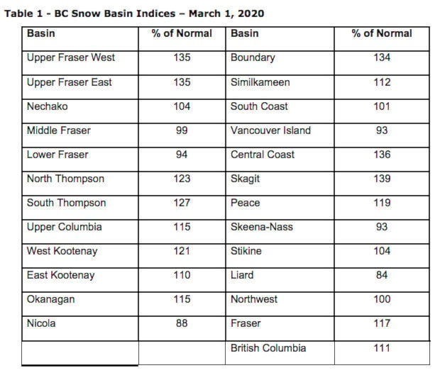
The Boundary basin still has among the highest average snowpacks in the province as of March 1, when the most recent provincial snow survey, completed at the beginning of the month.
Sitting at 134 per cent of normal, the Boundary’s overall pack is two percentage points under where it was in March 2018, and more than double that measured last year.
Nevertheless, last month didn’t see a ton more accumulation of snow, and instead saw nine days reach above 5 C at lower elevations, and more than a dozen more warm up above freezing as well, facilitating some melt lower down in the watershed.
“The conditions haven’t gotten worse since Feb. 1, but they haven’t necessarily gotten better,” said Jonathan Boyd, a hydrologist with the River Forecast Centre.
The overall provincial level reported in the report released March 9 was 110 per cent.
Some areas of the Kootenays have received record amounts of precipitation, like the Redfish Station, which records levels in a creek that drains into Kootenay Lake. Other areas in the north Slocan and Arrow Lakes areas are recording levels more than 140 per cent of normal.
“For snow-melt dominated rivers in the interior of the province, the likelihood of spring flooding increases with high snowpacks; this is most pronounced when snow basin index values approach or exceed 120 per cent,” notes the March report. “This does not mean that spring flooding will occur, rather the chances of flooding are increased.”
The report is based on data collected from over 200 automated and manual snow monitoring stations scattered at high elevations across the province.
SEE: West Kootenay snowpack nearing record levels
The report says while the snowpack could potentially get deeper, it’s not likely to shrink much until the big spring melt.
“The snowpack won’t lessen, unless we have a significant warm spell in the rest of March,” said Boyd, though he notes the long-range forecast doesn’t predict much warming. “We’ll still see the snow increase for at least the next week, though it might get dryer.
“But the big help in flooding would be having a really hot start to April, and melt away some of that lower-elevation snow, and then have it go cool for a week and then have another warm spell.”
Typically, 80 per cent of the annual snow accumulation has occurred by March 1, with another four-to-eight weeks of snow accumulation still to come, the report says.
It says while changes to the overall provincial seasonal flood risk are possible over the next few months (either increases or decreases), current trends in snowpack are likely to persist.
The report says after a wet January, precipitation was more modest across B.C. in February.
Coastal areas, including Vancouver Island and the South Coast, had below-normal precipitation. In the B.C. Interior February precipitation was near-normal to above-normal for most areas. In the West Kootenay, the month saw precipitation roughly half of normal.
High snowpack levels are one factor in determining if there will be flooding during the spring freshet, or snow melt.
The report notes discrepancies in long-range forecasting on spring weather. But the Centre can’t say if that increases the likelihood of flooding.
“Seasonal weather forecasts produced by Environment and Climate Change Canada in late February are indicating an increased likelihood of cooler than normal temperatures for March through May for most of British Columbia […] Similar seasonal forecasts from NOAA favour near-normal to above-normal temperatures across BC through the spring,” the report says.
“Discrepancies between these two models may be an indication that the temperature and teleconnections currently present are creating increased uncertainty over the outlook for seasonal weather this spring.”
The forecasters will head into the mountains again at the end of March to get a sense of how the snowpack continues to develop.
With files from Jensen Edwards
https://www.castlegarnews.com/news/west-kootenay-snowpack-very-high-getting-deeper/