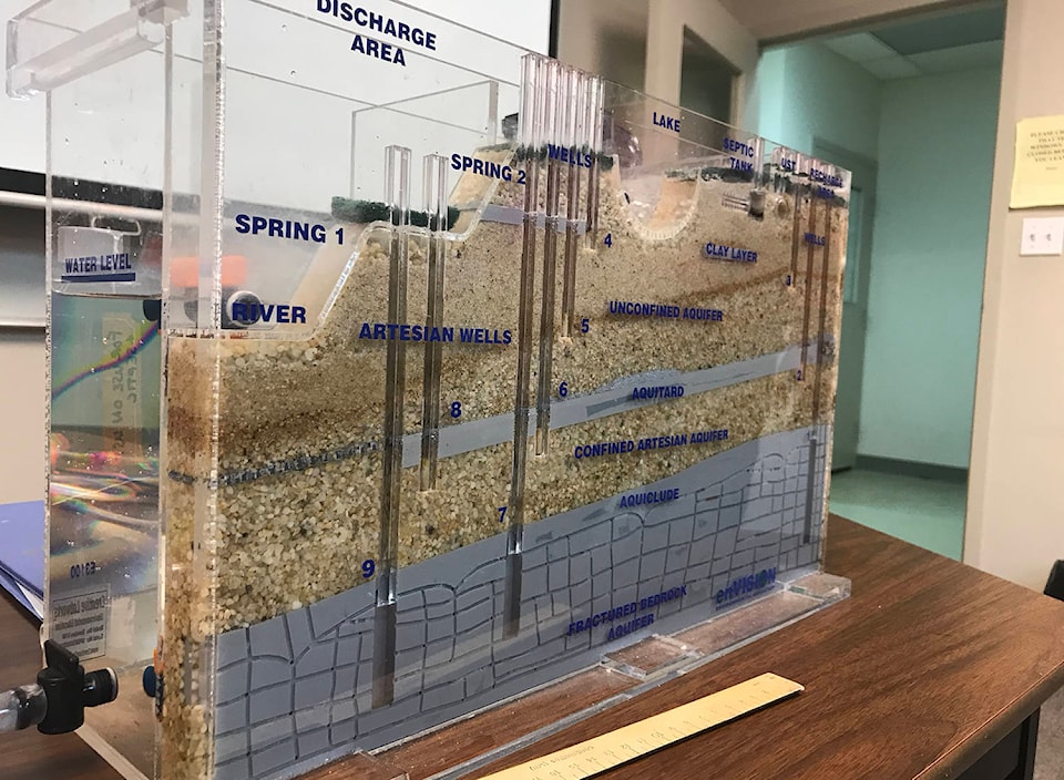
A packed classroom at Selkirk College in Grand Forks watched coloured water sift its way through sediment layers in an aquifer model last week during a presentation on ground water from the Regional District of Kootenay Boundary’s Kettle River Watershed planner, Kristina Anderson.
In the first of a series of what Anderson hopes will be helpful public information and learning sessions, Anderson and Selkirk College hydrologist Allison Lutz walked residents through the journey water takes through the Kettle Valley.
“A lot of our streams in the Kootenays and globally really rely on water from aquifers, especially in August and seasons where we’ve got low flows,” Lutz said. “At times of the year where the river level is high, you actually have an influent condition, where the river is feeding the aquifer. So it’s there’s back and forth there.”
Consequently, Anderson explained, excessive well usage can effect stream levels, particularly during drought.
“If we’re at a well that is a very strong-pumping well and we’ve got a very low water system in the stream, we’re going to start looking at the wells, [to figure out what’s going on],” Anderson said.
With the help of her model and student Justin van Hoogevest, Lutz demonstrated how local aquifers are replenished, polluted, used and refreshed and how they are affected by what goes on above ground. In unconfined aquifers such as those along much of the Kettle River, which are not capped by slabs of solid rock above, surface waters are absorbed more quickly. Couple with large and solid materials on top, such as concrete, and groundwater has a higher chance of being polluted.
Concrete, for instance, “prevents water from getting down and recharging the groundwater system,” Lutz explained. “It also makes it run off more quickly and it’s carrying with it things like salt or oil or gasoline or whatever seeps out of our vehicles.”
Other sources of pollution can include buried gas tanks, septic systems improperly set up and fertilizers.
In addition to learning about how are local aquifers are fed, attendees learned about how much information they could glean online about their own wells, like well logs, meant to document the layers of soil, sediment and rock dug through while drilling a well, and which are available online through iMap BC.
The provincial data mapping tool allows the public to interact with their area and provincial information about it.
“There’s a lot of information out there,” Anderson said, “and I’m pretty keen on being able to get some of that information to some people,” she said of the impetus behind the public information sessions.
“Even if you don’t know how to get to it, you know that it’s there. And you know that you can ask somebody or you to ask those questions afterwards.”
While Anderson said she is looking to host more information sessions on different topics in the new year, no dates have yet been set.
@jensenedw
Jensen.edwards@grandforksgazette.ca
Like us on Facebook and follow us on Twitter.