The February 1 snow survey by the BC River Forecast Centre was released this week.
The provincial weather pattern shifted in January, switching from very cold and relatively dry conditions in late December to wetter conditions for the first half of the month. Predominantly drier weather persisted throughout much of B.C for the latter half of the month. Temperatures in January ranged from 0.0 to +3.0˚C above normal. The warmest anomalies were centred in the Northwest and the South Interior.
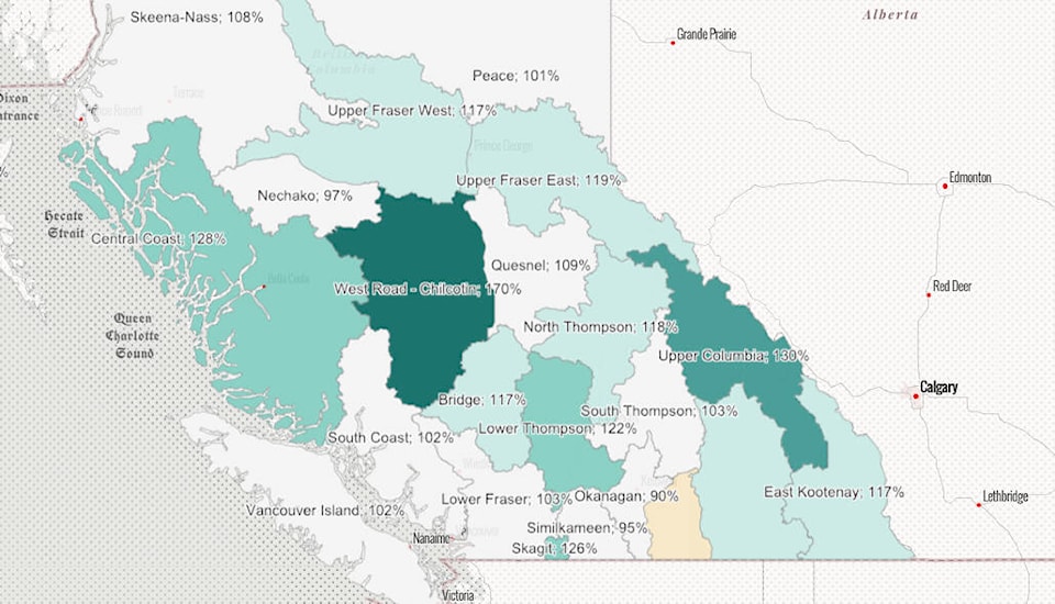
The East and West Kootenay snow packs are down slightly from values in December, at 117 and 116 per cent of normal respectively.
By early February, nearly two-thirds of the annual B.C. snow pack has typically accumulated. Snow pack throughout the province ranges from 88 to 142% of normal.
Upcoming weather forecasts predict generally dry conditions to persist through most of B.C. for the upcoming week. The provincial average for all snow measurements across the province is 110% of normal and indicates a higher risk for snowmelt related flooding during the spring months (freshet), particularly for the Interior. With a few months left for snow accumulation, seasonal snow packs can still change significantly, the report says.
READ: Snow packs in East and West Kootenay above normal
carolyn.grant@kimberleybulletin.com
Like us on Facebook and follow us on Twitter