One-hundredth in a series on West Kootenay/Boundary place names
How did the Boundary get its name? It’s after Boundary Creek, but why isn’t the region named instead after the Kettle River, the much larger body of water to which the creek is tributary?
It appears mineral claims staked along Boundary Creek made it a byword for the region.
The earliest known mention of “Boundary Creek district” is in the Ainsworth Hot Springs News of Sept. 21, 1892: “[G]reat developments are promised in the Boundary creek district, where there are very rich deposits of copper and silver-lead …”
The first use of “Boundary district” is in the Nelson Miner of Sept. 30, 1893: “The reports of the Kettle River gold strike have not yet been verified as yet, although there are many in the Boundary district who accept them as gospel.”
The first known mention of “Boundary country” is in the Nelson Miner of Jan. 25, 1896: “The development of this property will be an excellent thing for that section of the Boundary country.”
By 1897, the Boundary Creek district was defined in Mining in the Pacific Northwest as “the area between the mouth of Rock Creek on the west and the north fork of the Kettle River on the east, between the [US border] on the south and the source of Boundary Creek, 12 miles north.”
How did Boundary Creek get its name? Greenwood’s Kim Kinakin posed this question recently, pointing out that many areas along the US-Canada border could be called Boundary Country and Boundary Creek doesn’t straddle the border, but starts well north of it, crosses into the US near Midway, and then flows into the Kettle River not far south.
The first recorded mention of the creek is in the Victoria British Colonist of Jan. 3, 1861 which also reveals an alternate name: “The usual route taken by the Dalles’ traders to reach American Creek, after ascending the Forks of the Okanagan is to take the Hope trail from that point to Tonasquet City or Rock Creek — a distance of about 25 miles. Thence, they descend the Colville or Dease's river (as Anderson’s map calls it) to American Creek, which, by the way, is better known in that region as Boundary Creek.”
The first mention of American Creek was just a few days earlier, in the Colonist of Dec. 28, 1860, while the last was in the New York Times in September 1861.
How the creek was named was revealed in a letter from Robert Stevenson, a former customs collector at Osoyoos, published in the Colonist on Nov. 19, 1891. He repeated the comments in the San Francisco Call in 1896, but near as we can tell, they’ve never been mentioned since.
Stevenson wrote: "In September 1860, I was gold mining on Rock Creek when the American Engineers and the British Engineers, then locating the 49th parallel and putting up the monuments, met near Boundary Creek, the British Engineers coming from the west, I think, and the Americans from the east. Well, as I said, the parties themselves met, but their surveys did not by over 300 yards!
“The British line was north. Each party kept on, and before they ceased operations the two lines had lapped fully 30 miles! At first it was presumed the Americans were in error, and some of Uncle Sam's subjects built stores close up to the northern, or British line, at Boundary creek, and called the place 'American Town' …” (Italics in original.)
So Boundary Creek denotes the discovery of a major surveying goof. It turned out the American line was correct. Stevenson added: “The whole thing was kept very quiet and there are few living today who know anything of the mistake, and during these 30 years I have never once seen it mentioned in any newspaper, but, nevertheless it is true …”
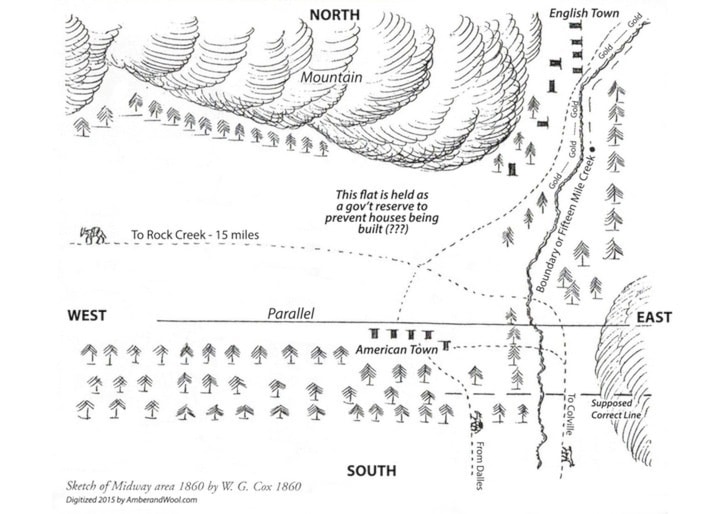
One-time Victoria mayor Joseph Carey, who worked for the American Boundary Commission, disputed Stevenson’s statements. However, a map drawn by justice of the peace William G. Cox in 1860 and published in the Boundary Historical Society’s 13th report, supports Stevenson: it shows American Town, as well as English Town to the northeast, and “Boundary or Fifteen Mile Creek” with the notation “Gold – gold – gold” along it (but completely omits the Kettle River).
It also shows both parallels — the correct one and incorrect one — nearly 400 yards apart. Judging from the map, American Town existed just southwest of the intersection of Dominion St. and Thomet Rd. in Midway. In 1891, Stevenson said “no trace exists of the place except the remains of some stone chimneys.”
Previous installments in this series
Applegrove, Appleby, and Appledale revisited
Bakers, Birds, and Bosun Landing
Bannock City, Basin City, and Bear Lake City
Bealby Point (aka Florence Park) revisited
Boswell, Bosworth, Boulder Mill, and Broadwater
Brooklyn, Brouse, and Burnt Flat
Camborne, Cariboo City, and Carrolls Landing
Carmi, Cedar Point, Circle City, and Clark’s Camp
Carson, Carstens, and Cascade City
Christina City and Christian Valley
Cody and Champion Creek revisited
Champion Creek revisited, again
Columbia City, Columbia Gardens, and Columbia Park
Crawford Bay and Comaplix revisited
Dawson, Deadwood, and Deanshaven
English Cove and English Point
Forslund, Fosthall, and Fairview
Fort Shepherd vs. Fort Sheppard, Part 1
Fort Shepherd vs. Fort Sheppard, Part 2
Gladstone and Gerrard, revisited
Granite Siding and Granite City
Hall Siding and Healy’s Landing
Hudu Valley, Huntingtdon, and Healy’s Landing revisited
Inonoaklin Valley (aka Fire Valley)